Introduction - The following tables summarize citywide land use data for the year 2000 and for the proposed land use under the recommendations of the 2020 Citywide Plan. Differences in the categories between the tables are the additions of the “Mixed-use: Residential/Retail” and “Mixed-use: Downtown” categories under the Proposed Land Use table, which are reflective of one of the Plan’s major land use recommendations which is to encourage more mixed-use development in order to promote more walkable and transit-friendly neighborhoods. For a more detailed description of the uses under each land use type refer to the Land Use Definitions. |
| Citywide Land Use -2000 |
Proposed Citywide Land Use -2020 |
| |
|
Land Use Type |
Acres |
% |
 |
Land Use Type |
Acres |
% |
Vacant Land |
2,755 |
5.5 |
|
Single- and Two-family |
16,495.6 |
33.1% |
Single-and Two-family |
14,456 |
29.0 |
|
Townhouse |
425.5 |
0.9% |
Townhouse |
110 |
0.2 |
|
Mixed-use: Live-Work |
51.5 |
0.1% |
Mixed-use: Live-Work |
15 |
0.0 |
|
Multi-family |
1,389.6 |
2.8% |
Multi-family |
1,832 |
3.7 |
|
Mixed-use:Residential/Retail |
770.7 |
1.5% |
Office |
357 |
0.7 |
|
Mixed-use: Downtown |
210.7 |
0.4% |
Retail |
1,591 |
3.2 |
|
Office |
512.4 |
1.0% |
Commercial Service |
800 |
1.6 |
|
Retail |
1,349.4 |
2.7% |
Light Industry |
3,171 |
6.4 |
|
Commercial Service |
983.3 |
2.0% |
Heavy Industry |
3,253 |
6.5 |
|
Light Industry |
3,905.9 |
7.8% |
Institutional |
3,144 |
6.3 |
|
Heavy Industry |
2,304.4 |
4.6% |
Recreation/Open Space |
3,495 |
7.0 |
|
Institutional |
3,000.1 |
6.0% |
Transportation/Utilities |
6,936 |
13.9 |
|
Recreation/Open Space |
4250 |
8.5% |
Commercial Parking |
181 |
0.4 |
|
Transportation/Utilities |
6,422.9 |
12.9% |
Local Streets |
7,476 |
15.0 |
|
Commercial Parking |
38.1 |
0.1% |
Water |
317 |
0.6 |
|
Local Streets |
7,462.1 |
15.0% |
TOTAL |
49,889 |
100.0 |
|
Water |
317 |
0.6% |
|
|
|
|
TOTAL |
49,889.2 |
100.0% |
(Note: The numbers in the proposed land use table does not reflect proposals in the City’s Waterfont Plan to construct new land and islands in Lake Erie for Port of Cleveland and open space development)
Summary - In addition to a proposed increase in mixed-use development, the Plan proposes continued development of townhouses as an appropriate housing option for the City’s urban neighborhoods. The numbers also show a proposed increase in open space which reflects plans to increase access to the lakefront and to extend and make connections to the Towpath Trail and the Ohio and Erie Canal Reservation. As a result the proposed figure for transportation/utilities is reduced as the peripheries of Burke Lakefront Airport are proposed for open space. The numbers also show a proposed increase in office and light industrial uses with a corresponding decrease in heavy industry. The level of retail use is generally expected to remain the same, even though the pattern of retail development may change. Although the acreage for Retail is less in the proposed land use table due to consolidation of retail into nodes, mixed-use developments often include retail as a component. In some cases a reduction in acres for a land use category in the proposed table is partly a function of the mapping. Whereas it is expected that closed schools and obsolete multi-family structures will be redeveloped for other uses, some of the reduction for the Institutional and Multi-family categories results from generalizing the land use on the proposed land use map.
Citywide Land Use Maps – Click on the following links to access existing and proposed land use maps for the City.
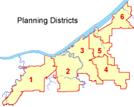
Planning District Land Use – Downloadable land use maps and tables for each planning district are available by clicking on the pdf buttons below. |
|
|
Citywide (All 6 Districts in one file) ** |
|
|
District 1 |
|
District 4 |
|
|
District 2 |
|
District 5 |
|
|
District 3 |
|
District 6 |
**This is a relatively large file (13MB) and may take longer to download on a slow connection. |
|